 |
|
In this second WACOM project newsletter, we would like to present the legal background of the WACOM project and some of the achievements achieved in the first year of its implementation on Work package T1: Explore and define joint preparedness and response and Work Package T2: Develop joint preparedness and response toolbox.
|
|
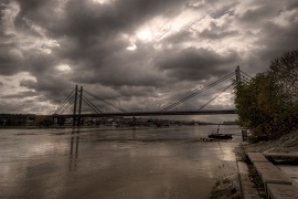
The WACOM project which started on 1st of July 2020 and ends in December 2022 is co-funded by the European Union funds (ERDF, IPA).
Legal background of the WACOM project
Recognizing the vital importance of transboundary cooperation, the Parties of the Framework Agreement on the Sava River Basin (FASRB) (Slovenia, Croatia, Bosnia and Herzegovina and Serbia) should undertake measures to prevent or limit hazards and reduce and eliminate adverse consequences of floods and incidents involving substances to water among other objectives of the FASRB. They are also obliged to establish a coordinated or joint system of measures, activities, warnings, and alarms in the Sava River Basin for extraordinary impacts on the water regime such as sudden and accidental pollution, discharge of artificial accumulations and retentions caused by collapsing or inappropriate handling, flood, ice, drought, water shortage, and obstruction of navigation. The FASRB was signed on December 3 2002, at Kranjska Gora (Slovenia) and entered into force on December 29 2004 after the ratification by all Parties. The International Sava River Basin Commission, which is the international partner of the WACOM project, is a body responsible for the implementation of the FASRB. It coordinates the activities of the Parties in establishment of an international regime of navigation, establishment of sustainable water management and undertaking of measures to prevent and limit hazards.
In implementing of the FASRB, the Parties have already concluded four protocols (i.e. Protocol on Navigation regime, Protocol on Prevention of Water Pollution Caused by Navigation, Protocol on Flood Protection and Protocol on Sediment Management), while the Protocol on Emergency Situations is foreseen to be harmonized in near future. The status of the protocols is indicated below and will be implemented through three protocols of the WACOM project.
Prevention of Water Pollution Caused by Navigation signed in Belgrade (RS), 1 June 2009, In force since 8 October 2017
Flood Protection, signed in Gradiška (BA), 1 June 2010, in force since 27 November 2015
Emergency Situation, Final harmonization expected

The existing systems for exchange of the information like Flood Forecasting and Warning System for the Sava River Basin (Sava FFWS) and the Accident Emergency Warning System (AEWS) are operational and will, if necessary, be tested and upgraded within the WACOM project.
Work Package T1: Explore and define joint preparedness and response
The process of mapping institutions, procedures and activities has been completed in the first half of 2021. The mapping was conducted in five countries (Slovenia, Croatia, Bosnia and Herzegovina, Serbia, Montenegro) and from the international aspect (mostly procedures that include the activities of the International Sava River Basin Commission).
The process of mapping institutions, procedures and activities was carried out within three areas – civil protection, water management and river navigation and at different levels (strategic, tactical, and operational) with a particular interest in existing procedures in force. The entire mapping process was conducted and finished in an extremely dynamic environment (during the COVID-19 pandemic lockdown in all countries for most of the time) to meet multiple functions to follow the initial project assumptions/settings and to examine the current situation. It also served as a gap analysis to identify specific areas where it is necessary to change and/or create new procedures and as a basis for the organization and implementation of the first four national workshops.
First state (national) workshops were organized during May and early June 2021 in four countries: Bosnia and Herzegovina (May 11); Croatia (May 19); Slovenia (May 27); Serbia (June 2). All workshops were organised as a one-day event, the first three were conducted online while the last was conducted in hybrid mode. The reason for conducting online workshops is due to the COVID-19 pandemic.
All four workshops had a very successful outcome. Thematically, all workshops had the same structure. The WACOM project and the most significant activities of the International Sava River Basin Commission were presented in the introductory part. The central part was made up of two blocks., Analyses of state (national) systems of institutions, procedures and activities were presented in the first block while the second block presented the ICS system and its capabilities. Each block was followed by the discussion between the workshop participants and the presentation of the results of the discussions. In addition to the participants of the WACOM project, the workshops were attended by a significant number of representatives of Target groups who, with their contribution and comments, confirmed the correct direction of action in the project.

Work Package T2: Develop joint preparedness and response toolbox
Modelling component enabling modelling of oil slick propagation
The main goal of the Work Package T2 (WP2) is the development of a rapid joint preparedness and response toolbox, which will be built in harmonisation with the operational family of tools developed and used by the International Sava River Basin Commission (ISRBC), i.e. GeoInformation System for the Sava River Basin (Sava GIS), Hydrological Information System of the Sava River Basin (Sava HIS) and Flood Forecasting and Warning System in the Sava River Basin (Sava FFWS). The modelling module of the toolbox will be based on two-dimensional (2D) hydraulic and oil spill propagation modelling, with the oil spill modelling being based on the precalculated hydraulics of the river sections. Therefore, the first major task within WP2 has been the development of local 2D hydraulic models.
The hydraulic modelling has been conducted for approximately 700 km long section of the River Sava, with modelling area stretching from Čatež in Slovenia to Belgrade in Serbia. Propagation models for Slovenia were already developed in the previous project financed by the URSZR. The considered modelling area has been divided into larger reaches of the River Sava, with the reaches defined between larger tributaries. Thus, modelling domain has been regrouped into 13 river reaches: (1) Čatež – Sutla, (2) Sutla – Bregana, (3) Bregana – Krapina, (4) Krapina – Kupa, (5) Kupa – Una, (6) Una – Vrbas, (7) Vrbas – Orljava, (8) Orljava – Bosna, (9) Bosna – Tinja, (10) Tinja – Drina, (11) Drina – Bosut, (12) Bosut – Kolubara, and (13) Kolubara – Beograd.
In the second stage, the river reaches have been further divided into 31 modelling sections, with the model limits being set at natural boundaries (e.g. river confluence) or at relevant infrastructure (e.g. ferry line, harbour etc.). The idea has been to divide the modelling area into different modelling sections by considering where the potential source of pollution might occur or the spilled oil might enter the main river channel (e.g. confluence, industrial complex etc.) and where the potential response and mitigation measures might be deployed (e.g. ferry line, bridge etc.). The extent of the modelling area and modelling sections can be seen in the Figure below.
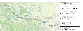 Figure: The extent of the modelling area and modelling sections
The 2D hydraulic modelling has been performed using the RiverFlow2D model, which has been developed by Hydronia LLC. RiverFlow2D is a combined hydrologic(al) and hydraulic mobile bed and pollutant transport finite volume model for rivers, estuaries and floodplains. The RiverFlow2D model can route floods in rivers and simulate inundation over floodplains and complex terrain at high resolution with remarkable speed, stability and accuracy. The 2D hydraulic models are based on a flexible mesh system, where the model domain is represented by a network of triangular elements that form a connected mesh.
The current model mesh sizes have been selected in order to provide an adequate level of resolution for the purposes of the project while allowing model simulations to be performed in a reasonable timescale on available computer configuration. However, as the mesh size is flexible, it is possible to use the same models with a finer or coarser mesh size to enable simulations of longer periods of time or to obtain higher resolution outputs within acceptable computation timescales. An example of the 2D computational mesh can be seen in Figure below.
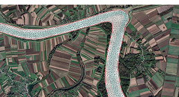 Figure: An example of a model mesh with the underlying terrain grid
In the following stages of hydraulic modelling, the focus will be set on running the models for different range of low flows, and potential model refinements through model calibration/validation processes. As mentioned, the hydraulic modelling will form the basis for the subsequent oil spill modelling. Prior to the start of the oil spill modelling, we have thoroughly reviewed the scientific literature in the field of river oil spill modelling in order to analyse the state-of-the-art river oil spill modelling techniques and identify gaps in the knowledge. Our analysis has been published in a respected scientific journal and is available at the journal’s website (link).
In addition, testing and selecting of appropriate oil spill model have already been conducted, with OilSpill2D model being selected as the preferred choice. OilFlow2D model, also developed by Hydronia LLC, computes oil trajectories in rivers by incorporating the effects of oil weathering processes (i.e. evaporation, emulsification, dissolution and interaction of oil with shores) with the OilFlow2D computation engine being based on an accurate, fast and stable finite-volume solution method. The oil spill modelling will be based on the precalculated hydraulics of an individual river section, which should enable simple development of different oil spill scenarios and faster oil spill model runs.
Upcoming events
In September 2021, the regional workshops will be organized to create a starting point for the preparation of the tabletop exercise scheduled for May 2022. Based on a hypothetical emergency spill and flood events and a simulation scenario, the roles of institutions and the limitations and risks of successful implementation of the planned exercise will be discussed. As part of the tabletop exercise, the communication and decision-making processes and the complex response to emergency events of relevant institutions (i.e. national and local authorities, infrastructure companies and enterprises) from the Sava riparian countries will be discussed. The outcomes of regional workshops will help the project partners to improve the outcomes of other work packages and prepare the basis for the further development of joint preparedness and response toolbox (WP T2) and implementation of pilot actions (WP T3).
The regional workshops are scheduled as follows: September 9, Brežice (SI), September 16, Slavonski Brod (HR) and September 23, Županja (HR).
We would like to invite you to follow the activities on the WACOM project at the project website and social media, i.e., Facebook and Twitter where the upcoming events will be announced in a due time and the information on the implementation of the WACOM project will be regularly updated.
