|
Transboundary data exchange systems in operation in the Sava River Basin
The access to data and information on the water regime is very important for the good water management and with the ratification of the Framework Agreement on the Sava River Basin (FASRB) the Parties have agreed to exchange data and information on a regular basis.
In Article 10 of the Protocol on Flood Protection to FASRB, the Parties have agreed to ensure timely exchange of meteorological and hydrological data, analyses and information important for flood protection, especially the timely forecast of high flows, in line with the agreed procedure, through the hydro-meteorological services and institutions responsible for flood protection.
Beside the FASRB and the Protocol on flood Protection represent also a Policy on the Exchange of Hydrological and Meteorological Data and Information in the Sava River Basin was signed by national/entities hydro-meteorological services and water agencies in 2014. It is fully consistent with World Meteorological the Resolutions 25 (Cg-XIII) and 40 (Cg-XII) and it is consistent with the United Nations Economic Commission for Europe Water Convention (Article 13) -– which encourages riparian Parties to exchange data on the environmental conditions of transboundary waters.
The Policy provides:
- A framework for sharing hydrological and meteorological data that the signatories want to exchange under their own arrangements and;
- A minimum level of “core”, regularly data exchange.
It allows the signatory organizations to continue, and expand, ad-hoc data sharing on a project-by- project basis, while also securing a minimum amount of ‘core’ data exchange which is vital for the effective management of the basin.
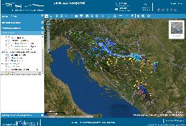
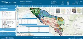
The FASRB, the Protocol and the Policy represent the legal basis for establishment of the Sava Geoportal (www.savagis.org) where the following datasets are available:
- 1st and 2nd (working version) Sava River Basin Management Plan datasets
- 2nd Sava River Basin Analysis data and metadata
- 1st and 2nd (working version) joint Sava Preliminary Flood Risk Assessment report datasets
- 1st Sava Flood Risk Management Plan datasets
- Integrating data on cultural and historical heritage in floodplains of the Sava River Basin
- Processed hydrological and meteorological data of selected gauging station
Within the WACOM project further improvements and development of new functionalities of the SavaGIS platform is planned, including the development of navigation and accident prevention modules, as well as development of advanced reporting tools and decision support system in the course of 2022.
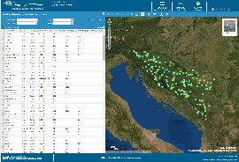
The real time hydrological and meteorological data are available in Sava Hydrological Information System (SavaHIS) (www.savahis.org). The number of hydrological and meteorological stations in Sava HIS is continuously increasing, primarily due to the needs of Sava Flood Forecasting and Warning System. Nowadays more than 300 hydrological stations and more than 200 meteorological stations are included in the SavaHIS.
 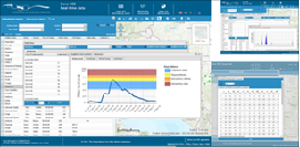
The online data from the hydrological stations will also be linked with the joint preparedness and response toolbox which will be developed by the WACOM project.
Work Package T1: Explore and define joint preparedness and response
In the second half of 2021, the central focus within the T1 Work Package was the preparation, organization, and implementation of regional workshops. A total of three workshops were planned and successfully conducted. All of them were conducted in person with the participation of project partners and target group institutions. In addition, some project partners and target group institutions observed the workshops and actively participated online. The purpose of the workshops was to create a dialogue regarding existing procedures within and between countries, all to collect input data needed for the preparation of table-top exercises to be conducted during 2022. From the workshops, key conclusions and recommendations can be derived, as follows.
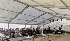
First regional workshop was held in Brežice (Slovenia) on 9th September 2021. The first set of conclusions regarding the challenges and obstacles in the preparation and execution of table-top exercises stated that good predictiveness of the scenario is, in the initial stage, a safe solution and improves the performance of an exercise. Additionally, this workshop resulted in a couple of conclusions: simulation is of great importance because the river is a dynamic object, situational awareness is crucial, and media should not be the primary source of information in these situations. Furthermore, conclusions noted that there is a role of hydropower plans as most relevant and that it is necessary to define the role of the coordinator of the response.
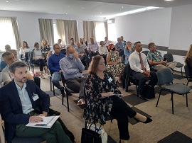
The second regional workshop was held in Slavonski Brod (Croatia) on 16th September 2021. Participants of this workshop concluded that it is necessary to work more and improve horizontal and vertical communication within organizations and between different groups; continuous education and awareness of risks and potential emergencies is needed, followed by education of employees within various institutions. Furthermore, conclusions stated that the WACOM project should provide recommendations and solutions and preferably propose the joint action program to prevent pollution from navigation or terms of reference for developing an information system for mutual information and action/monitoring of such and similar operations.
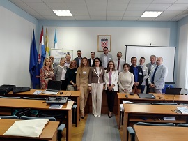
The third regional workshop was held in Županja (Croatia) on 23rd September 2021. During the discussion, participants talked about the bottleneck regarding the simulation of the table-top exercise. They concluded that representatives of institutions are interested in continuing the cooperation in connection with the exercise preparation in May 2022. Nonetheless, all experts emphasized a need for non-governmental and private sector involvement in the flood defense emergency and accidental pollution management.
Brežice (SI)- 9th Sept. Slavonski Brod (HR)- 16th Sept. Županja (HR)- 23rd Sept.
Finally, although various things were highlighted in the workshops as recommendations and conclusions, when viewed in their entirety, a complete set of the most critical views and opinions on the key things to be included in the preparation of table-top exercises was obtained. In addition, all the above recommendations and conclusions show the current situational picture regarding the challenges of coordination, communication, and cooperation between different actors. These observations represent valuable insights for the WACOM project and the states and institutions involved.
Work Package T2: Develop joint preparedness and response toolbox
The WACOM project is among other issues addressing also a specific challenge of improved response in the case of water emergencies - accidental pollution and floods. The response in the reality of water emergencies is extremely heterogeneous, and require participation of different sectors (water management, civil protection, navigation, police, special units etc.), different levels of government (central government, regional institutions, local government), private stakeholders, water users, and even more could be listed.
A specific challenge of the WACOM project was therefore an identification of suitable framework for the exchange of information and coordination of the plethora of identified institutions in the transnational context. The transnational context of course means that the identified set of institutions and necessary coordination effort is additive by each added country involved in the improved response mechanism.
With the analysis of current development in the domain of civil protection, it was soon identified that three of four countries participating in the WACOM project are each in its own specific pathway relative to the adaptation of the incident management processes following the USA – National Incident Management System (NIMS), and it’s specific component – Incident Command System (ICS). Within the elaborations of the WACOM project ICS was identified as suitable for the definition of the key transnational emergency processes addressed in the WACOM project, certainly with several adaptations necessary.
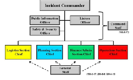 Definition: ICS is a standardized on-scene emergency management construct specifically designed to provide for the adoption of an integrated organizational structure that reflects the complexity and demands of single or multiple incidents, without being hindered by jurisdictional boundaries. ICS is the combination of facilities, equipment, personnel, procedures, and communications operating within a common organizational structure, designed to aid in the management of resources during incidents. It is used for all kinds of emergencies and is applicable to small as well as large and complex incidents. ICS is used by various jurisdictions and functional agencies, both public and private, to organize field-level incident management operations. Definition: ICS is a standardized on-scene emergency management construct specifically designed to provide for the adoption of an integrated organizational structure that reflects the complexity and demands of single or multiple incidents, without being hindered by jurisdictional boundaries. ICS is the combination of facilities, equipment, personnel, procedures, and communications operating within a common organizational structure, designed to aid in the management of resources during incidents. It is used for all kinds of emergencies and is applicable to small as well as large and complex incidents. ICS is used by various jurisdictions and functional agencies, both public and private, to organize field-level incident management operations.
The key adaptation performed by the WACOM project was the selection of key components of the ICS system which will be incorporated into the WACOM defined processes, and certainly also the components of the ICS which are left to national jurisdiction. The components which are of no transnational importance are clearly those, related to the decision making process. The decision making is part of the national sovereignty, and above all related also to the issue of administrative and financial framework of the emergency. It ws therefore the task of the WACOM project, partners and target groups to identify the components of this standardized communication framework, which are related to the improved response in the case of transboundary water emergencies. The identified components were:
Maintained exchange of contact information on active participants in the emergency – following the ICS 207 form – “Incident Organization Chart”, with the implementation of this reporting an exchange of information on all active institutions will be enabled in the transboundary (Sava river basin scale) framework.
Maintained, well-structured daily reporting providing information on the status of the incident and response – following the ICS 209 form – “Incident Status Summary”, with the implementation of this reporting an exchange of information status of the incident will be shared among institutions and countries enabling efficient and effective situational awareness and improved decision making. The situational awareness and planning potential is also supported by the forecasts of accidental pollution propagation and flood forecasts.
Maintained, well-structured daily reporting on the planned activities for the next operative period – following the context of ICS IAP – “Incident Action Plan” – enabling exchange of information on the planned activities for the next operational period.
The WACOM activities in the work package 2 are currently focused to the development of the reporting system toolbox (WACOM toolbox) which will enable the exchange of information on ICS 207, ICS 209 and IAP on target web site supported with the GIS user interface.
Work Package T3: Verify joint preparedness and response - pilot implementation
Work Package T3 (WP3) follows and builds on previous packages in which preparedness and response tools were developed and in which the existing preparedness and response system was defined. Tools and response protocols in case of pollution that are being developed are adapted to the existing organizational matrix of each nation, as much as possible as this is the basis for the life of the project after its completion and it also gives the highest probability that WACOM tools will be adopted at the national and inter-state level.
The specifics of the organizational matrix of each country are considered in two ways: First is the finding of a common denominator among all national disaster response schemes (number of activated organizations, their hierarchy and information protocols, etc.). In this context, WACOM tools must be sufficiently generalized to be implemented in different levels of the hierarchy in such a way that they do not interfere with existing communication protocols, regardless of the organizational matrix of each country. The second level considers the fact that disasters on the Sava River move downstream, which means that the point of contact between the two areas of national organizational structures is very clearly defined, namely the point (and narrower area) where the river crosses the state border. The latter enables sufficiently independent contact of organizational matrices, which do not intertwine but operate independently with certain lines of communication. These findings, derived from WP1 and WP2, are essential and provide a solid foundation for the realization of WP3.
The goal of WP3 is to organize table-top exercises, and to achieve this, WP3 consists of several steps. The first is the preparation of documents defining disaster scenarios (two cases of accidental pollution of the Sava River and three cases flooding of the Sava River). The second is the preparation of documents to define the response to disasters according to the organizational schemes of each country, the specifics of each region and the inclusion of WACOM tools. The third is the preparation of a project-plan that will give detailed instructions on how to perform a table-top exercise. A separate set of documents will be used to independently assess the success of the table-top exercise, followed by reports with conclusions and proposals for exercises in the future that could further improve disaster preparedness. The latter is also a part of project-life after its completion.
Table-top exercises are one of the goals of the WACOM project and a lot of attention is invested in these events.
Five exercises will be organized, one in each country participating in WACOM. That is why the regional workshops were conducted in 2021 and contacts were established with stakeholders who will also be invited to participate in table-top exercises. These exercises are specific of the WACOM project, as there are very few or no such exercises in the Sava River Basin countries. Therefore, WACOM provides a unique opportunity for actors involved in disaster rescue, protection, and rehabilitation to train, improve their skills and competences and form cross-sectoral links, with purpose of increasing effectiveness at carrying out their rescue, protection, and rehabilitation activities when disaster occurs.
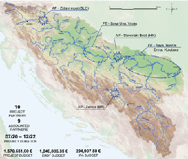
Locations of the emergency events at Zidani most (SI), Slavonski Brod (HR) and Zenica (BA)
Upcoming events
The table top exercise described in the previous chapter are scheduled to be held in May 2022.
We expect that the stakeholders of the WACOM project will recognize the potential of these exercises. With their cooperation, the table-top exercise will be memorable and experience-full event and an example of good practice in performing of simulations of emergency events management because of accidental pollution and floods.
We would like to invite you to follow the activities on the WACOM project at the project website and social media, i.e., Facebook and Twitter where the upcoming events will be announced in a due time and the information on the implementation of the WACOM project will be regularly updated.
|