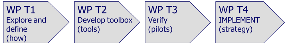
This is the 4th newsletter of the Water Contingency Management in The Sava River Basin (WACOM) indicating the major activities on Work Package 2 and Wark Package 3.
The main objective of the WACOM project is the reduction of environmental risks related to accidental pollution and floods, especially with potential transboundary impact by improved cooperation of key actors and jointly developed common operational system for activating the accident management protocols within the Sava River Basin. Beside the reduction of risks, project will also bring overall improved transnational cooperation in the Sava River Basin which requires specific attention, developing improved ties among people, institutions and countries. The WACOM covers the implementation of the Framework Agreement on the Sava River Basin (FASRB) and three protocols to the FASRB, i.e. Protocol on flood protection, Protocol on prevention of pollution caused by navigation and the Protocol on emergency situations.
WP 2: DEVELOP JOINT PREPAREDNESS AND RESPONSE TOOLBOX, Improvement of the savaGIS and links to new modules
The main objective of the WACOM project is the reduction of environmental risks related to accidental pollution and floods, especially with potential transboundary impact by improved cooperation of key actors and jointly developed common operational system for activating the accident management protocols within the Sava River Basin. Beside the reduction of risks, project will also bring overall improved transnational cooperation in the Sava River Basin which requires specific attention, developing improved ties among people, institutions and countries. The WACOM covers the implementation of the Framework Agreement on the Sava River Basin (FASRB) and three protocols to the FASRB, i.e. Protocol on flood protection, Protocol on prevention of pollution caused by navigation and the Protocol on emergency situations. With the FASRB and protocols the Parties have agreed to exchange data and information on water regime and the regime of navigation on regular basis.
In 2009, International Sava River Basin Commission (ISRBC) established vision, principles and objectives for development of Geo-Information System of the Sava River Basin – SavaGIS within the Sava GIS Strategy. The further conceptualization and proposal of SavaGIS architecture has been done in 2010 within the Implementing Documents for Establishment of Sava GIS, which defined the following modules of SavaGIS platform:
- Integrated River Basin Management
- Flood Management
- Navigation Management
- Accident Prevention and Control
- Sediment Management
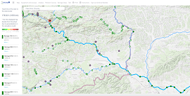
In 2015 all preparatory steps finally resulted in the establishment of a functional SavaGIS system, operational through its Geoportal (www.savagis.org), for exchange of data and information related to the integrated river basin management and flood management - Integrated River Basin Management and Flood Management modules. As integral part of SavaGIS, ISRBC has also established the Hydrological Information System for the Sava River Basin (www.savahis.org), for exchange of hydrological and meteorological data and information taking into account the Policy on the Exchange of Hydrological and Meteorological Data and Information in the Sava River Basin. To further enhance the functionalities of the existing system and to meet the Implementing Documents for Establishment of Sava GIS requirements, ISRBC aims to develop Accident Prevention and Control and Navigation Management modules functionalities as integral part of the SavaGIS platform. These modules, forming the basis for joint data exchange activities stipulated by the FASRB, shall provide necessary tools for navigation and water pollution information exchange and dissemination in the Sava River Basin.
The target groups, beside the ISRBC and its expert bodies, which will have benefits from the project, are mainly:
- National public authorities responsible for transboundary cooperation in the case emergency events caused by floods and accidental pollution i.e. Ministries, agencies, directorates),
- Local public authorities organized in the form of local communities and first responders on the local level (e.g. firefighters),
- Infrastructure and (public) service providers managing traffic, drinking water and waste water,
- Enterprises (e.g. hydropower companies, transport companies, industrial establishments where dangerous substances are present, mining companies).
The main goal of the Sava GIS upgrade activities is:
- To develop (design, test, deploy and implement) SavaGIS database elements for the Navigation management and Accident prevention and control data within the existing SavaGIS platform repository;
- To develop (design, test, deploy and implement) Navigation management and Accident prevention and control modules on existing SavaGIS platform for storing, processing, dissemination and visualization of corresponding information;
APC module consists of:
- Pollution accident risk information management - potential accidental pollution hazard site locations - location of accidental pollution site facilities (point, line and polygon data types), with potential accidental pollution hazard (attributes defining the type, category and other parameters of hazard site). Examples: locations of main industrial establishment (obliged to implement the Seveso and the Industry Emission Directive), major roads, railways, and similar;
- Pollution accident event information management (pollution source and propagation model) - locations on the Sava River affected by pollution – pollution event insertion, automatic search by location, management of river network and downstream propagation along the network logic, downstream distance and time visualization; Pre-calculated propagation velocities model along the hydrographic network integration, (propagation velocities model and river network topology will be provided to the service provider); Sava River hydrological stations discharge retrieval, hydrological stations discharge interpolation (interpolation logic will be provided to the service provider); Location visualization and visualization of the status of the river discharges from the Sava River hydrological stations.
- Response measures for the mitigation of the accidental pollution information management - potential locations on the rivers for the implementation of the response measures (point data type - intervention access to rivers), with a set of attributes defining the type, category and other parameters of access site; Agencies, companies and other institutions with specific authority in the case of accidental pollution (polygon data type – area of management), with a set of attributes defining the type, category and other parameters of competent authority; Equipment for remedy adverse effect classification; Guidelines for the response measures (sub-page with the guidelines, guidelines will be provided to the service provider).
NAV module consists of:
- Electronic Navigational Charts information management
- Electronic Navigational Charts display
- Album of bridges on the Sava River and its navigable tributaries information management, integration and display
- Existing Web application for Navigation Safety Inspection Support System entry point
- Existing Web application for the development of the Marking Plan for the Sava River and its navigable tributaries entry point
- Existing Indicator of river kilometres for the Sava River and its navigable tributaries information integration
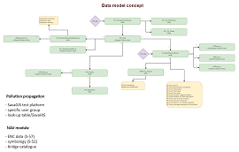
Following the inception phase and acceptance of the Inception report, current project activities involve the specification of Data model and Functional specification deliverables:
- Data model document represents a specification of the implementation level data model of the Navigation (NAV) and the Accident Prevention and Control (APC) modules on the SavaGIS platform.
- Functional specification document represents a specification of data import and validation functionalities, data exchange format and adjustments of the SavaGIS platform content and functionalities corresponding to newly developed modules and thematic layers.
WP 3: VERIFY JOINT PREPAREDNESS AND RESPONSE-PILOT IMPLEMENTATION, Pilot tabletop exercises simulating the incident and response of tranboundary accidental pollution and flood events
WACOM reaches one the most important milestone – execution of tabletop exercises!
In May 2022, the WACOM project reached an important milestone – the physical implementation of tabletop exercises (TTXs) for 5 different accident events: 3 accidental pollution events and 2 flood events.
The preparation and execution of the exercise in the form of tabletop exercises (TTXs) are part of the project’s main outputs within work package T3. The idea of conducting the exercises is linked to the project outputs within work package T2, which is development of new tools to support and improve transnational coordination in disaster responses, to improve situational awareness during disasters and to provide help in modelling the propagation of pollution. The TTXs served as testing and training ground for pilot utilisation of the new tools.
One of the important project objectives, which subsequently determines the conditions of individual disaster scenarios, is that disasters must have cross-border effects, cross-border coordination and activation of forces. This ensures that the WACOM project follows the objectives as set by the countries committed to the international Framework Agreement on the Sava River Basin (FASRB).
First preparations for the implementation of TTXs began in early 2021, when the project partners formulated the basic ideas and objectives that they wanted to achieve with the TTXs. Based on the project partners’ experience in the theory of staff exercises, the framework for conducting the exercises was determined and the method of the exercise was chosen, which enabled further preparation of exercise implementation documents. The key documents prepared as part of work package T3 for the implementation of TTXs are the Event Scenario, Contingency and TTX Implementation Report.
The TTX scenario is a document that describes the disaster event itself, whether pollution or flood. The Contingency Plan determines the response activities to a specific accident and it includes. The Contingency Plans prepared for each of the five WACOM scenarios combine existing plans and well-established procedures for the coordination and activation of stakeholders, and at the same time provide new instructions on utilisation of the WACOM tools in coordination and response to accidents.
The most important document prepared prior to the TTXs is the TTX Implementation Report. This document specifies the execution details, execution location, agenda, execution steps, and content of the TTX and MSEL (Master Scenario Event List) timeline, which provides a detailed schedule of the response of individual exercise participants.
Execution of TTXs
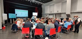
The first of the five planned TTXs was held in Brežice, Slovenia. It hosted more than 60 participants forming 9 active headquarters, 5 from Slovenia and 4 from Croatia, while some participants took part only as observers.
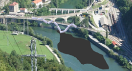
The exercise was led and coordinated by Dr. Primož Banovec, Assoc. Prof., representing the University of Ljubljana as the lead partner. The TTX scenario considered a train accident occurring at one of Slovenia’s major railway junctions – Zidani Most. According to the scenario, a large amount of oil would leak from freight wagons into the Sava River, and the stain would then propagate further downstream towards the Posavje region and the national border with Croatia.
The TTX was conducted so that the participants at the headquarters had to actively participate in the TTX, present their planned activities during the interventions, describe the communication methods and existing practices in the exchange of information, coordinate activities between the headquarters. For the WACOM project, the important part of the exercise was the utilisation of the new WACOM tools, which the participants used for the first time within the TTX.
The tool for improving transnational situational awareness and the tool for improving coordination during interventions were used in the disaster briefing, response engagement and reporting stage, while the pollution propagation modelling tool was used in the planning stage to improve both coordination of forces out in the field and to improve the situational awareness.
After the TTX was carried out, a survey and a rapid TTX analysis was conducted as part of the HOT-WASH panel discussion in order to reach common conclusions on the TTX execution. The headquarters participants gave their opinions, suggestions and comments regarding the implementation of the TTX.
The second and the third TTXs were organized in Slavonski Brod (Croatia) on May 18-19. The scenarios considered were major accidental pollution because of grounding of the ship and the transboundary flood event in the area of Una, Vrbas and Sava Rivers. More than 50 participants gathered from the relevant institutions from Croatia and Bosnia and Herzegovina.
The fourth and the fifth TTX were held in Brčko (Bosnia and Herzegovina) on May 23-24 where the scenarios were focused on accidental pollution because of spilling of large quantity of oil at the location of Zvornik (BA) and to the transboundary flood event on Drina and Sava Rivers. About 30 participants were present, mainly from the institutions from Bosnia and Herzegovina
All the TTXs were well received by participants and WACOM partners gained a lot of feedback and ideas for further work, particularly on the finalisation of the project, which is set to close by the end of 2022.
Upcoming events
Until December 2022 following major events will be organized within the WACOM project:
- Sava Youth Parliament, October 13-14, 2022
- Final Conference, November 14, 2022
We would like to invite you to follow the activities on the WACOM project at the project website and social media, i.e., Facebook and Twitter where the upcoming events will be announced in a due time and the information on the implementation of the WACOM project will be regularly updated.
